

In
the closing paragraph of the previous post, Invisible Bordeaux was
poised to enter Bordeaux via the inland route from Le Bouscat as
followed over the years by thousands of Way of Saint James pilgrims on their way to Santiago de Compostela
in north-western Spain: the “el Camino de Santiago” pilgrimage known in France as “les Chemins de Saint-Jacques-de-Compostelle”.
The 8.4-km route through the city itself, which has been added to the Invisible Bordeaux GoogleMap, leads out of Le Bouscat along Avenue de Tivoli. A small square marks the official arrival in Bordeaux... and that may just be a scallop-shaped sculpted feature there to greet the pilgrims!
 The path enters Bordeaux proper on Rue de Tivoli, leads onto Rue Fondaudège
before heading south towards Rue Capdeville and the first major landmark
of interest to pilgrims, Saint-Seurin Basilica.
The path enters Bordeaux proper on Rue de Tivoli, leads onto Rue Fondaudège
before heading south towards Rue Capdeville and the first major landmark
of interest to pilgrims, Saint-Seurin Basilica.
The 8.4-km route through the city itself, which has been added to the Invisible Bordeaux GoogleMap, leads out of Le Bouscat along Avenue de Tivoli. A small square marks the official arrival in Bordeaux... and that may just be a scallop-shaped sculpted feature there to greet the pilgrims!

Saint-Seurin Basilica
When UNESCO
registered the routes of Saint James’ Way pilgrimages as world heritage in
1998, Saint-Seurin was one of three churches in Bordeaux listed as key monuments
associated with the pilgrims’ path.

Saint-Seurin was originally built in the 6th century then overhauled and extended between the 12th and 14th centuries, partly to be a more prominent sight for pilgrims passing through. The basilica boasts some fine samples of Christian carvings and sculptures, and an impressive pipe organ which was first installed in 1776.
In the early years of the 20th century, archaeological digs uncovered a large Christian cemetery with graves dating from the 4th to the 18th centuries, including those of Saint James' Way pilgrims! Excavations revealed a set of walls that formed constructions from different periods housing fresco-decorated tombs and pottery storage jars that were used to bury infants. The haunting underground site can be visited afternoons between June and September.
The path then proceeds across Place Gambetta, along Rue de la Porte-Dijeaux and Rue Saint-Rémi to the quayside and down towards Porte Cailhau – the first port of call for pilgrims arriving in Bordeaux directly from the right bank.
Porte Cailhau

Porte Cailhau was the
fortified main gate into the medieval incarnation of Bordeaux. It was erected
in 1495 and its sculptures pay tribute to King Charles VIII, who had recently
conquered the kingdom of Naples in the company of Cardinal d'Epernay, Archbishop of Bordeaux. When the gate was built, the river bank stretched
all the way up to the fortifications of the city. Rugged edges show where the gate was connected to the adjoining city walls, and differently-shaped smooth paving stones serve as a reminder of where the walls once stood.
From here on, it is now easy to track the pilgrims' progress through the heart of Medieval Bordeaux, by following the bronze studs that have been positioned on the ground (as pictured at the top of the article). The route loops around past the 14th/15th-century Saint-Pierre church and Place Saint-Projet (once the city's central "forum", later a cemetery, now a lovely square) to Rue du Loup, which in turn leads through to Place Pey-Berland and Saint-André cathedral, the second of the city’s churches to be recognised by UNESCO as emblematic landmarks on the pilgrimage route.
From here on, it is now easy to track the pilgrims' progress through the heart of Medieval Bordeaux, by following the bronze studs that have been positioned on the ground (as pictured at the top of the article). The route loops around past the 14th/15th-century Saint-Pierre church and Place Saint-Projet (once the city's central "forum", later a cemetery, now a lovely square) to Rue du Loup, which in turn leads through to Place Pey-Berland and Saint-André cathedral, the second of the city’s churches to be recognised by UNESCO as emblematic landmarks on the pilgrimage route.
Saint-André Cathedral

The
cathedral and its twin spires were built between the 12th and 16th
centuries and formed the backdrop to two royal weddings: that of Aliénor
d’Aquitaine and the future king Louis VII in 1137, and that of Louis XIII and
Anne of Austria in 1615. The scale of the church is awe-inspiring, with a
23-metre-tall nave that stretches over 124 metres. The separate 66-metre-tall Pey-Berland belfry was completed in 1500.
Place Fernand-Lafargue
On to Place
Fernand-Lafargue, which was granted its own Invisible Bordeaux feature a few
months ago! In medieval times, this square was a veritable hive of activity
what with the crowds, the animals, the public criers… and the public pillory!
Pilgrims were probably relieved to head down Rue Saint-James (note the name!) towards Porte
Saint-Éloi...
Porte Saint-Éloi

The 13th-century Porte Saint-Éloi was one of the main gates to and from the heart of the city and a natural extension to the existing Saint-Éloi church. Given the steady stream of Saint James Way pilgrims, it was also known as Porte Saint-James. The Grosse Cloche (Great Bell) belfry was added in the 15th century and has become one of the best-known landmarks in Bordeaux, visible on the city’s coat of arms.
Saint-Éloi church was originally built in the 12th century, although the gothic construction which can still be seen today was completed in 1245. It fell into disuse in the 1980s and even became a squat. A Catholic non-profit association set about renovating the church in the early years of the 21st century, and in 2007 it became a working church once again.
Leading south is Rue du Mirail, where Hôpital Saint-Jacques was located from the 12th century onwards. It was a haven where pilgrims could spend the night, as well as serving as a hospital for many of the city’s poor until at least the 16th century. Nothing remains today and the area where the hospital was located is privately-owned. The last remaining catacombs collapsed in 2001 although it is reported that a sculpture of Saint James came through unscathed.
Turning left at Hôtel Saint-François provides the shortest route to Saint-Michel.
Saint-Michel church
Église Saint-Michel may be the last of the three main places of worship along the pilgrims’ route in Bordeaux, but is possibly the stand-out point of interest as Saint James travellers have their own dedicated chapel.
This flamboyant gothic church was built between the 14th and 17th centuries. Again, the belfry stands apart from the main edifice (as with Saint-André, the instability of the Bordeaux soil was the reason behind this decision). The “Flèche de Saint-Michel”, as it is known, tops out at 114 metres!

The chapelle
Saint-Jacques, as it has been known since the 17th century, is located to the right-hand side of the church. Its centrepiece is a 16th-century painting
representing the apotheosis of Saint James. Below this is a 17th-century wooden
altar which was restored in 1992. The grave of a pilgrim can also be seen. The
reproduction of a 15th-century statue of Saint James is positioned in front of the chapel (bottom
left picture). The statue itself could be viewed in the church itself for many years, but is now on display at the Musée d’Aquitaine
(bottom right picture). The stained-glass windows, which also aim to recount
the story of Saint James, are far more recent. They were produced in 1963 by master
craftsman Jean-Henri Couturat.
The path then winds back towards what is now Place de la Victoire and down the linear Cours de l'Argonne.
Croix de carrefour de la Barrière Saint-Genès
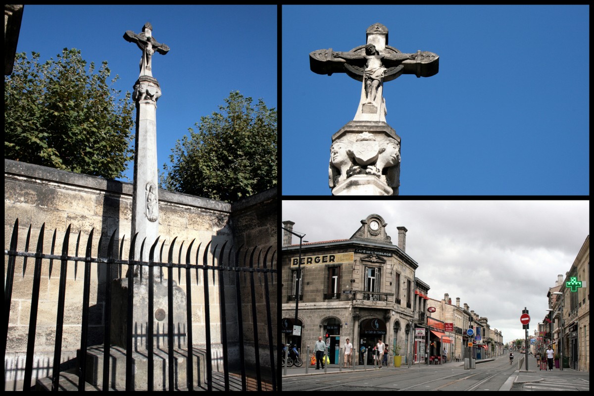
The final
sight for pilgrims before they officially leave Bordeaux and enter the suburb
of Talence is this 14th-century “croix de carrefour”, a cross originally from
the cemetery of the nearby Saint-Genès church (long gone) which was previously used
to mark the centre of the junction. The cross was restored first in 1606 then
in 1902, which is when it was repositioned to where it can now be found, tucked away
from the main road.
And that is where we shall leave the pilgrims' path for now... although I plan to track the sections from Lamarque to Le Bouscat, the variants that cross the Médoc, and the route through Talence, Gradignan and beyond in future articles. To be continued!
- Find them: square and sculpture, Saint-Seurin Basilica, Porte Cailhau, Saint-André Cathedral, Place Fernand-Lafargue, Porte Saint-Éloi,
- Detailed information about Saint-Seurin, Saint-André and Saint-Michel churches.
- Full guide to the Paris stretch of the pilgrimage on partner website Invisible Paris!
- Thanks to Harvey for pointing out the "croix de carrefour" which I would otherwise have missed!
- Maps showing full itinerary through the area.


0 commentaires: